Wednesday, March 30, 2016

Unit 3: Rivers and coasts - managing impacts of river flooding

Managing flood risk

Follow the link for more info: 

Unit 3: Rivers and coasts - hazards and opportunities offered by rivers

River hazards 

Floods

Source: http://aquaten.co.uk/frequency-of-severe-flooding-across-europe-to-double-by-2050/

Effects of Floods         • Floods destroy drainage systems causing raw sewage           to spill out into bodies of water...
Source: http://www.slideshare.net/lseman/catastrophic-events-impact-on-the-ecosystem-nx-power-lite

River erosion

Source: http://www.kxii.com/home/headlines/Communities-on-both-sides-of-the-Red-River-affected-by-erosion-on-Highway-78-309147521.html
Source: http://www.wbur.org/2011/09/02/vermont-flooding-2

River opportunities

Living on a flood plain

"Floodplains provide a wide range of benefits to the ecosystem and community that include:
  • Flood storage and erosion control–offer a broad area for streams and rivers to spread out and accommodate temporary storage of flood water, reducing flood peaks and erosion potential
  • Water quality maintenance – reducing sediment loads, filtering nutrients and impurities, and moderating water temperature
  • Groundwater recharge
  • Biological productivity – providing fertile soils with high rate of plant growth and diversity, richer agricultural harvests, and healthier forests
  • Habitat for a variety of fish and wildlife, including rare and endangered species
  • Recreational opportunities – providing areas for active and passive activities, supporting the economic base
  • Open space" 
Source: http://snohomishcountywa.gov/955/About-Flooding-Floodplains-Benefits-and-

Living close to a delta

"Advantages:
-fertile soil for agriculture
-the deltas can trap pollutants before they flow into the gulf
-sediment that is deposited in the delta does not become turbidity in the gulf
-they create wildlife habits"


Source: http://geo-deltaic.blogspot.com.br/2011/05/advantages-and-disadvantages-of-river.html

Living close to a river

"So why do people live near rivers?

  • The land on a flood plain tends to be flat, which is helpful for building.
  • The river can be used for communications ;
  • or roads/tracks can easily be made on flat land;
  • The flat land makes growing and harvesting crops by machine easier;
  • Water is available for irrigation; eg for rice growing (dev);
  • Water supplies for domestic use/river for washing;
  • Disposal of waste, either directly into the river or by using the river to remove the waste;
  • Population pressure leaves them with no choice, as there is little land left;
  • Fishing in river/food supplies;"


Source: http://www.geographylwc.org.uk/GCSE/igcse/rivergcase/whylivenearriverr.html


Read source for more info on river assets and hazards:


http://thoughts.arup.com/post/details/457/rivers-asset-or-hazard

Unit 3: Rivers and coasts - River landforms

River valleys

Source: https://garsidej.wordpress.com/year-7/rivers/
Source: http://www.bbc.co.uk/schools/gcsebitesize/geography/water_rivers/river_profiles_rev1.shtml

Waterfalls

Diagram of how a waterfall forms
Source: http://www.ck12.org/user:a2VpdGhfYmFsZHdpbkBjY3BzbmV0Lm5ldA../book/Earth-Science/section/8.11/

Potholes

Source: http://www.coolgeography.co.uk/A-level/AQA/Year%2012/Rivers_Floods/Landforms/Landforms.htm

Meanders

Source: http://www.bbc.co.uk/bitesize/higher/geography/physical/hydrosphere/revision/3/

Oxbow lakes

Source: http://www.bbc.co.uk/bitesize/standard/geography/rivers/river_forming/revision/2/

Deltas

Source: http://www.coolgeography.co.uk/A-level/AQA/Year%2012/Rivers_Floods/Landforms/Landforms.htm

Levées

Source: http://greenfieldgeography.wikispaces.com/IGCSE+Rivers+and+GCSE+Rivers

Floodplains

Source: http://www.coolgeography.co.uk/GCSE/AQA/Water%20on%20the%20Land/Meanders/Landforms%20Meanders.htm

Unit 3: Rivers and coasts - River processes

Erosional river processes

Source: http://greenfieldgeography.wikispaces.com/IGCSE+Rivers+and+GCSE+Rivers

  • Abrasion (or corrasion): the wearing away of the bed and bank by the load carried by a river.
  • Attrition: the wearing away of the load carried by a river. It creates smaller, rounder particles. 
  • Hydraulic action: the force of air and water on the sides of rivers and in cracks. 
  • Solution (or corrosion): the removal of chemical ions, especially calcium, which causes rocks to dissolve.
Nagle, Garrett, and Briony Cooke. "Page 120." Geography Course Companion. Oxford: Oxford UP, 2011. N. pag. Print.

The main types of transportation

external image GCSERe6.jpg
Source: http://greenfieldgeography.wikispaces.com/IGCSE+Rivers+and+GCSE+Rivers

Deposition

Source: http://www.cssforum.com.pk/359768-post50.html
https://sites.google.com/site/geographyterrain/river

The work of a river

Source: https://sites.google.com/site/geographyterrain/river
Source: http://www.chartiersgreenway.net/hydrology.htm

Unit 3: Rivers and coasts - Hydrological characteriestics and processes which operate within rivers and drainage basins

Characteristics of rivers

River cross section


Source: http://water.usgs.gov/edu/streamflow2.html

The drainage basin

Source: http://www.sln.org.uk/geography/schools/blythebridge/GCSERevisionRiversDB.htm

Drainage basin processes

Source: http://www.i-study.co.uk/Rivers.html

Unit 2: Weather, climate and ecosystems - Hot desert case study - The Sahara desert

The Sahara desert

Content Cover Image

Follow the link for more info:

Unit 2: Weather, climate and ecosystems - Tropical rainforest case study - The Amazon rainforest

The amazon rainforest

Jaguar

Follow the link for info:


Unit 2: Weather, climate and ecosystem - Describing causes and effects of deforestation of tropical rainforest

Causes of rainforest deforestation

Source: http://rainforests.mongabay.com/0803.htm

Source: http://kids.mongabay.com/elementary/501.html

Effects of rainforest deforestation

Environmental & Economical Impacts
IMPACTS
Increased
Soil
Erosion
Disruption
of Water
Cycles
Reduced
Biodiversity
Climate
...
Short Term Environmental Effects
•  No trees anchoring the fertile soil
•  Erosion is sweeping the land into rivers
•  The...
Long Term Environmental Effects
•  80 % species can be found in tropical rainforests
•  Often unable to survive in the sma...
Economical Effects
•  Deforestation greatly influences many lives
•  In Southeast Asia deforestation contributed to migrat...
Source: http://www.slideshare.net/threeseconds/deforestation-causes-effects-and-solutions

Source: http://news.mongabay.com/2013/11/deforestation-may-hurt-u-s-agriculture-affect-monsoon-cycle/

Tuesday, March 29, 2016

Unit 2: Weather, climate and ecosystem - Characteristics of tropical rainforest and hot desert ecosystems

The characteristics of the equatorial ecosystem

Characteristics of vegetation in the rainforest Tall straight trunks  no side branches  Aerial roots of  epiphytes absorb ...
A  Discontinuous  Canopy of tree Crowns of the  Tallest trees 40 – 50m ( Emergent) B  25 – 40m  Continuous layer of  Main ...
Latosol Soil Characteristics Precipitation > evapotranspiration Rapid leaching Soil colour – red or yellowish red colour O...
Source: http://www.slideshare.net/vicci/ecosystems-revision
   
Source: http://www.oneworld365.org/company/rainforest-biodiversity-group
http://www.wernerbollmann.de/articles_english.html
http://www.rainforestcruises.com/jungle-blog/amazon-rainforest-fauna

The characteristics of the hot desert ecosystem

Source: https://onlinegeography.wikispaces.com/LW-Hot+Desert+Information

Animal adaptations -Camels Two rows of long eyelashes Adaptation  Function  Protect against blowing sand and the sun   Fat... Animal adaptations- Fennec fox Adaptation Function  large ears (about 15cm) help dissipate excess body heat on hot days in...
Other common animal adaptations   <ul><li>Panting  to reduce body heat </li></ul><ul><li>Secreting highly  concentrated ur...

Source: http://www.slideshare.net/spottyzebra/desert-biomes

Unit 2: Weather, climate and ecosystems - equatorial and hot desert climates

Climate factors

Source: http://www.slideshare.net/aloksir/factors-affecting-climate-30376399

Equatorial climate

Climate graph - Manaus, Brazil

Source: http://www.v-brazil.com/tourism/amazonas/weather-manaus.html

Hot desert climate

Climate graph - Shuwaikh, Kuwait

Source: http://worldclimates.blogspot.com.br/p/desert-climate.html


Unit 2: Weather, climate and ecosystem - weather data collection

Weather elements and the instruments to collect them

  1. Temperature
  2. Humidity
  3. Precipitation
  4. Pressure
  5. Wind

1. Temperature: Maximum-minimum thermometer

 
Source: http://www.walterproducts.com/products-main/measurement/temperature/thermometers/maximum-minimum-thermometer
https://golearngeo.wordpress.com/category/formula/

2. Humidity: Wet-and-dry bulb thermometer (hygrometer)

Source: http://www.psscientific.com/shop/humidity/analog-hygrometers/reedmodelwd-5wetdrybulbhygrometer.aspx
http://weatherweatherweather.blogspot.com.br/p/all-about-weather.html

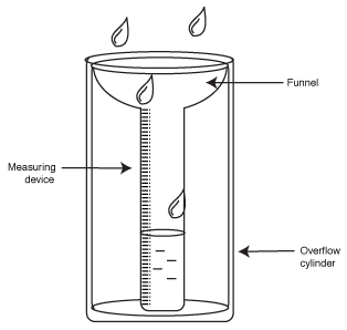
3. Precipitation: Rain gauge

 
Source: http://www.theolivecentre.com/Olive-Equipment/Weather-Monitoring/Rain-Gauge.html
http://www.factmonster.com/cig/weather/measuring-rain.html

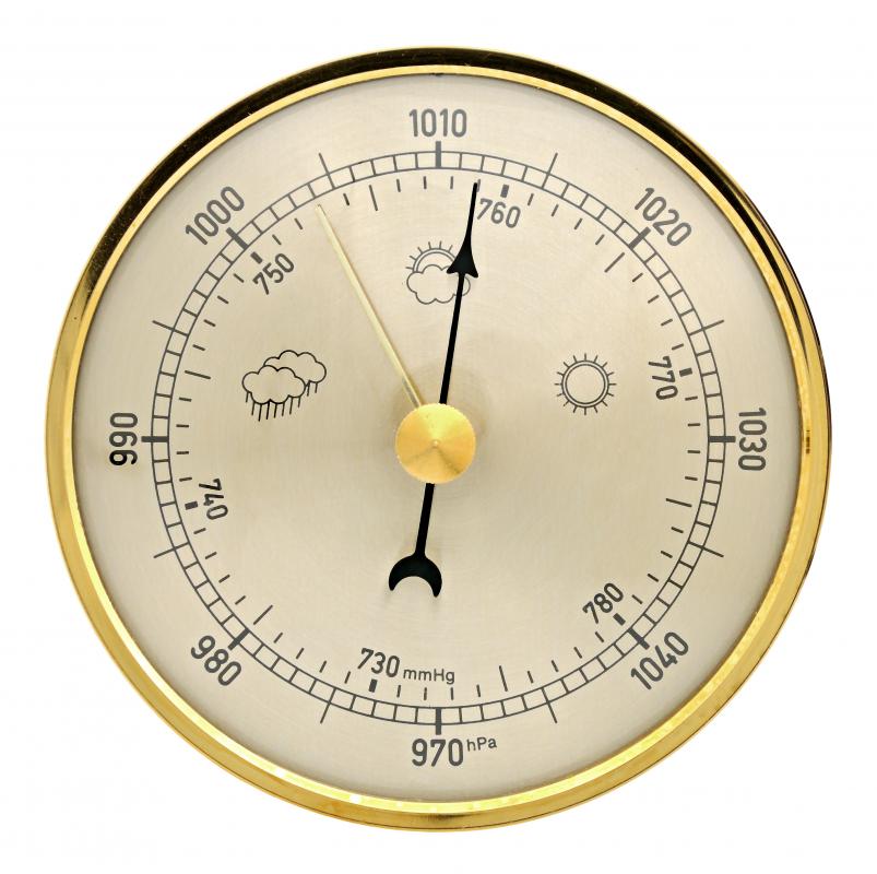
4. Pressure: Barometer

 
Source: http://www.wisegeek.org/what-is-a-barometer.htm

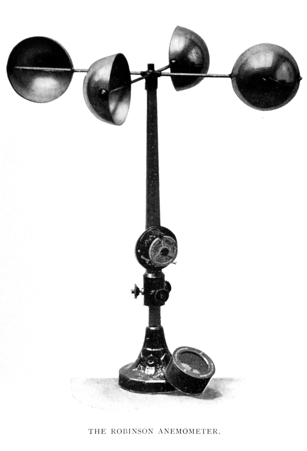
5. Wind: Anemometer and wind vane

 
Source: https://en.wikipedia.org/wiki/Anemometer
http://www.testolimited.com/testo-417-vane-anemometer
Source: http://www.wisegeek.org/what-is-a-wind-vane.htm

Some other instruments

Sunshine recorder

 
Source: http://www.kuriositas.com/2011/02/campbellstokes-sunshine-recorder.html
http://www.econet.org.uk/weather/sun.html

Stevenson screen

Source: http://www.bom.gov.au/climate/cdo/images/about/stevenson.jpg

The Stevenson Screen or thermometer screen is a standard shelter (from rain, snow and high winds, but also leaves and animals) for meteorological instruments, particularly wet and dry bulb thermometers used to record humidity and air temperature. 

It is kept 1.25m/4.1ft (UK standard) above the ground by legs to avoid strong temperature gradients at ground level, has louvred sides to encourage the free passage of air, and is painted white to reflect heat radiation, since what is measured is the temperature of the air in the shade, not of the sunshine.

Source: http://www.weatheronline.co.uk/reports/wxfacts/The-Stevenson-Screen.htm

Measuring cloud cover

Source: https://en.wikipedia.org/wiki/Okta
http://www.bbc.co.uk/bitesize/ks3/geography/physical_processes/weather_climate/revision/3/
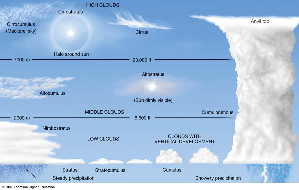
Types of clouds

Source: http://www.chemtrailplanet.com/CloudTypes.jpg

High clouds (6000 to 13000m)

Cirrus - Ci
Picture by Luís Carlos Torelli - UMAPAZ

Cirrocumulus - Cc
Picture by Luís Carlos Torelli - UMAPAZ

Cirrostratus - Cs
Picture by Luís Carlos Torelli - UMAPAZ

Middle clouds (2000 to 6000m)

Altostratus - As
Picture by Luís Carlos Torelli - UMAPAZ

Altocumulus - Ac
Picture by Luís Carlos Torelli - UMAPAZ

Low clouds (0 to 2000m)

Nimbostratus - Ns 
Picture by Luís Carlos Torelli - UMAPAZ

Stratocumulus - Sc
Picture by Luís Carlos Torelli - UMAPAZ

Stratus - St
Picture by Luís Carlos Torelli - UMAPAZ

Cumulus - Cu

Cumulus clouds are ranked by their size, they are all pre stages to a cumulonimbus. A cumulus fractus is a "piece of a cumulus cloud. 

CUMULUS FRACTUS < CUMULUS HUMILIS < CUMULUS MEDIOCRIS < CUMULUS CONGESTUS < CUMULONIMBUS
Picture by Luís Carlos Torelli - UMAPAZ

Cumulonimbus - Cb
Picture by Luís Carlos Torelli - UMAPAZ